
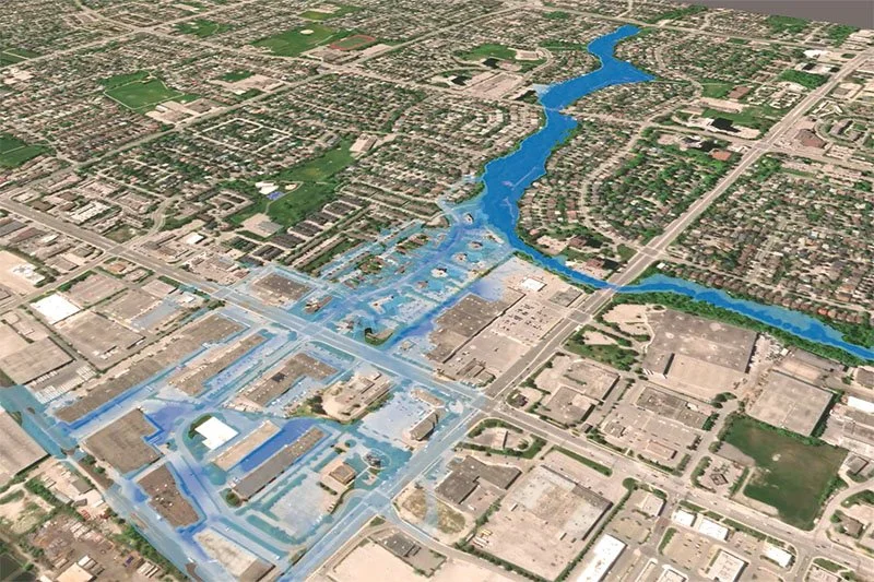
The team behind Envisioning Climate Futures uses visualization techniques to make flood modelling data come to life, with the goal of spurring action against climate change. Pictured here, a still image from a 3D visualization of a major flood scenario along Little Etobicoke Creek in Mississauga, Ontario.
When a wildfire ravaged Fort McMurray, Alberta, in 2016, 88,000 people were forced to flee their homes. As the embers cooled, residents confronted widespread devastation.
But the fire could have been even more damaging if the weather had been hotter, windier, or drier, says Ron Baecker, professor emeritus in the University of Toronto’s Department of Computer Science. And as climate change advances, those scenarios become more plausible.
The fire is one of several scenarios that Baecker and an interdisciplinary team of researchers across Canada are reinterpreting with the creative use of flood and fire modelling, data visualization, design, planning and environmental psychology.
Their ultimate goal: to spur individuals, communities and governments to take action against climate change and to give public agencies and citizen groups concrete tools for understanding and evaluating different choices.
The team behind Envisioning Climate Futures uses real extreme weather events to illustrate the predicted effects of climate action — or inaction.
"If we can show people that the floods and fires they're already worried about will get worse with inaction — but that concrete steps can make things better — I think that's a powerful way to get people and society to move," said Baecker.
Current approaches to climate communications fall into two camps, Baecker says. Some examples “show you masses of scientific data proving how bad it’s going to be, which can be very depressing. Others say, ‘Here are 100 things you could do,’ but they’re not connected to specific places or events people care about.”
This initiative aims to demonstrate the benefits of concrete action.
Starting with a documented extreme weather event, the team builds or adapts simulation models that they then validate — a key step that Baecker notes is one of the toughest technical challenges. The data required, like the water depth at specific locations during a flood, can be hard to access or of varying quality.
“We can systematically vary these models to show it getting worse if you do nothing and to show it getting better if you do some things,” Baecker explained.
But the model outputs themselves are “just a lot of numbers,” Baecker said, so the team works to convert the raw data into novel images and animations that can help people thoughtfully engage with the hypothetical scenarios. They hope to expand their visualization efforts into immersive experiences and even video games in the future.
By grounding its simulations in real rivers, creeks and communities, the project aims to turn abstract climate risks into local decisions that could spell the difference between crisis and resilience.
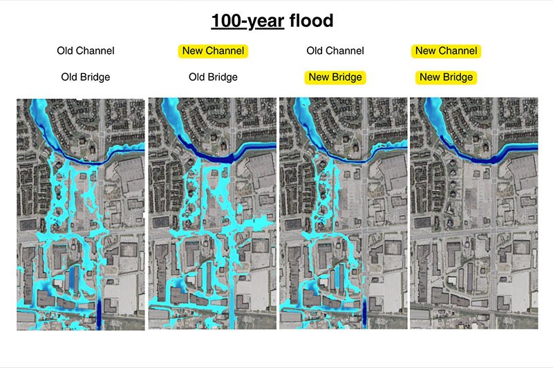
The researchers’ simulation of a major flood event in Little Etobicoke Creek demonstrated that both a proposed new channel and new bridge would be required to provide sufficient flood protection.
In one example, the researchers focused on the issue of flooding at a specific point along Little Etobicoke Creek in Mississauga, Ontario. Engineers' recommendations have included a new channel and a new bridge at a bend in the creek. The researchers recreated and visualized major flood events from 2013 and 2024 and found that both interventions would be required to mitigate anticipated damage in those scenarios — neither intervention alone would provide sufficient protection.
The team also applied its modelling to the recently reconstructed mouth of the Don River in Toronto, demonstrating much-improved flood resilience in the Port Lands area of the city.
The Envisioning Climate Futures team includes U of T computer science faculty members Fanny Chevalier, Steve Engels and Karan Singh, as well as John Danahy, professor emeritus of landscape architecture in U of T’s John H. Daniels Faculty of Architecture, Landscape, and Design. Ten U of T students and recent graduates contribute to the effort.
Other collaborators across Canada include experts from OCAD University, University of Prince Edward Island, Vancouver Island University and the Canadian Forest Service.
Looking ahead, the team has begun recreating the 2016 Fort McMurray wildfire in simulations and modelling coastal flooding scenarios in partnership with the Climate Smart Lab at UPEI. The researchers also hope to test experimentally whether their visualizations actually change how people think and act on climate.
“We’re not going to solve the climate problem by ourselves,” Baecker said. “But I’m only 83 years young — time to see what I can do.”